Apocalyptic EARTHQUAKE amid Turkey’s OIL WELLS. Highly Seismic Zone Drilled for Decades to Search Dadas Shale
[Nie wiem, czy ta hipoteza jesdt słuszna. Ale – na pewno prawdopodobna. Więcej obrazków oryginale. Mirosław Dakowski]
==========================
Summary: 1 – The Site of the Earthquake has been in the Sight of Oil Companies for Decades 2 – The Dangers of Drilling the Underground In Seismic Areas 3 – The Correlation between Drills, Subsidency dnd Earthquakes 4 – Hunt for Black Gold near The Earthquake Epicentre 5 – The Gaziantep and Kahramanmaras areas Reduced to a Colander
By Fabio G. C. Carisio
The disastrous devastation, the tragic massacre that took place in Turkey and Syria cannot and must not have only an emotional response. That of newspapers and TVs that compete to find the most heartbreaking photo and story. That of politicians who compete for the media scepter of benefactors.
It must also trigger rational reflection. This is why we do not consider it premature but rather a duty towards the families of the victims to seek a reason for what happened that goes beyond resignation to God’s mysterious designs.
As we have anticipated in previous investigations on the highly probable correlation between earthquakes and wells drilling, the greedy hand of man also emerges from the bloody rubble of this apocalyptic drama; increasingly unconscious in his confrontation with nature, as happened with the pandemic triggered by a SARS-Cov-2 virus created in the laboratory to sell and test new dangerous vaccines…
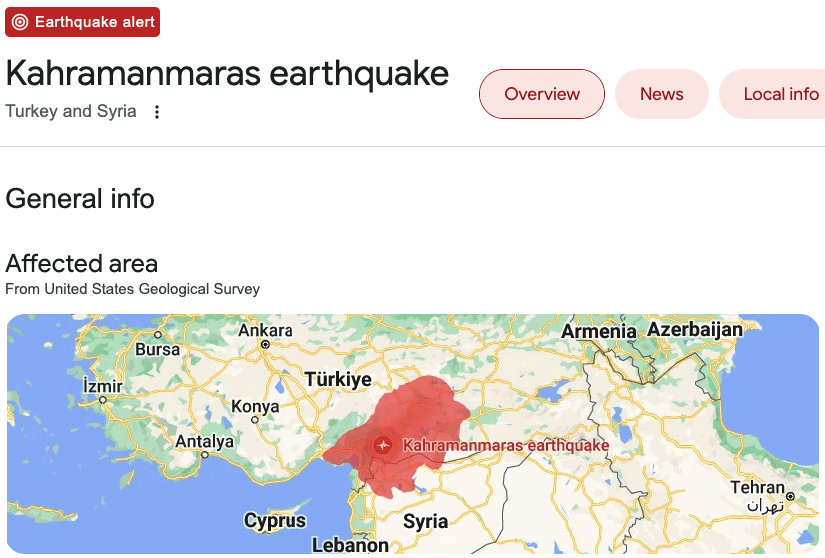
The first exploratory oil drillings in Kahramanmaraş, epicenter of the devastating earthquake that caused thousands of deaths in the Gazientep region, in south-eastern Turkey, and in the neighboring governorate of Aleppo in Syria, were conducted way back in 1991 as attested by a study by a Turkish geologist published in issue 113 of the Bulletin of the Mineral Research and Exploration (source 1 – the links at the bottom of the article).
1 – THE SITE OF THE EARTHQUAKE HAS BEEN IN THE SIGHT OF OIL COMPANIES FOR DECADES
«My first investigations relating to the Kahramanmaraş area took place in 1980 on behalf of a private oil company» wrote Yüksel Önem, one of Turkey’s top petroleum geologists now retired.
«The Taurus mountains, which developed in the conjoining zone of the Anatolian and Arabian Plates, underwent a disruption between Bolkar mountain and Engizek mountain. This can be explained by the fact that the area was traversed and transformed by two ma- jor strike-sup faults situated at Mersin-east Bolkar mountain-Kayseri in the west and Antakya (Hatay)-Elazığ-Bingöl in the east In fact, the east-west oriented 200 km. wide area, covering the gulf of İskenderun and the northern pan of Adana, was compressed and deflected as far as the north of Sarız and the Arabian Plate was dislocated prior to the faulting, and moved circa 120 km».
«Linked to this movement, the Miocene Nappe cover was dragged too far in the exactly opposite direction, i.e., to the south, and changed the original form of the mountain sequence. This relocation resulting from tectonic activities has emphasized, from the viewpoint of the settling of the forma- tions belonging to the Arabian Plate, the importance of the area north of Bolkar mountain-Engizek mountain line or the Taurus sequence and defined the hydrocarbon potential of Elbistan region. As to the Kahramanmaraş area, the fact that the oil-producing formations of the South- east Anatolia are found in this also, it continues to be an important objective».
Today around that country made famous by the black gold of the SE (South-East) Anatolian Basin, the vast Dadas Shale oil basin notoriously dangerous to extract due to the “fracking” technique with which rocks are broken at great depths, continues the count of victims is unstoppable.
More than 4,300 dead between Turkey and Syria. This updates the count of the victims of the devastating earthquakes that on Monday, February, 6,2023, destroyed thousands of buildings in southeastern Turkey and northwestern Syria. The Turkish authorities have brought their overall provisional death toll to 2,921, while the Syrian authorities have so far counted 1,444. The number of wounded, in Turkey alone, rose to 14,483.
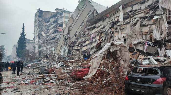
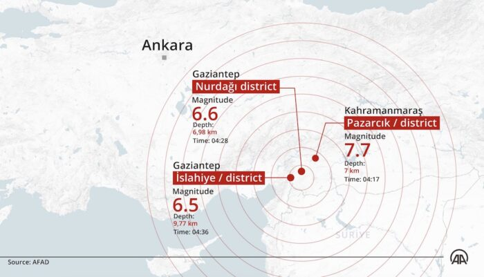
The update is growing hour by hour. In Turkey, at least 5606 buildings collapsed during and after the seismic wake which reached its peak with a 7.9 magnitude shock felt at 02:17 Italian time (04:17 local time + 2 CEST).
Salvatore Stramondo, director of the INGV Italian National Earthquake Observatory, explained to RaiNews24 microphones that the earthquake produced a release of energy that is about a thousand times higher than the Amatrice earthquake.
After the earthquake, an explosion was reported at a gas pipeline in the southern province of Hatay. This was reported by the Turkish press agency Ihlas, which quotes the operator Botas, according to which gas flows to the provinces of Gaziantep, Hatay and Kahramanmaras have been suspended.
2 – THE DANGERS OF DRILLING THE UNDERGROUND IN SEISMIC AREAS
Geophysical engineer Övgün Ahmet Ercan, according to the Hurriyet website. he said that he had a power of 130 atomic bombs and struck in “a highly seismic area, among those with the highest danger in the Mediterranean”.
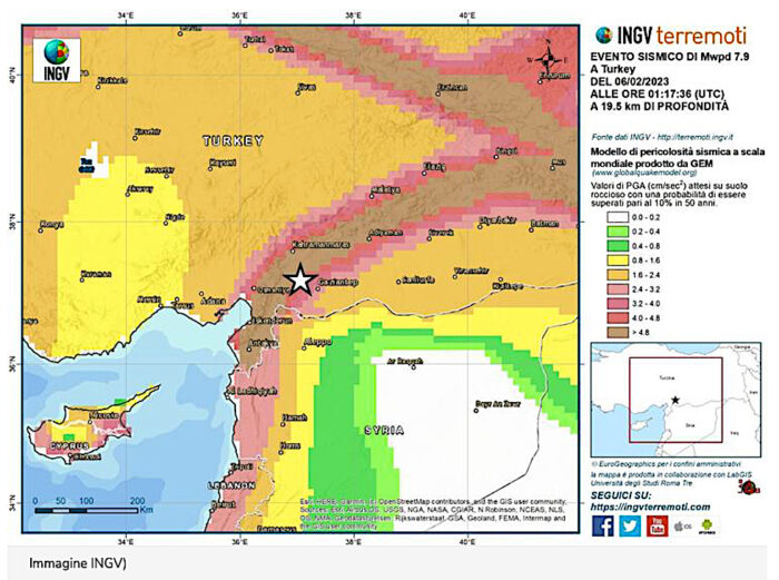
Today new tremors have hit the areas already devastated by the seismic swarm of the other night. The strongest of magnitude 5.6 according to the European Mediterranean Seismological Center (or 5.5 according to the United States Geological Institute) with epicenter is near the city of Gölbaşı, population 40,000, at a depth of about 2 kilometers.
“Turkey is located in a highly seismic area crossed by numerous fault systems: the area affected by tonight’s earthquake is considered to have a very high seismic hazard”.
This is explained by the seismologists of the National Institute of Geophysics and Volcanology (Ingv) who have drawn up and just published the worldwide Hazard Model produced by Gem.
But despite the danger, for about twenty years the subsoil has been drilled in search of black gold despite the fact that the cost/risk/benefit ratio has been deemed incongruous by an article of Dr. Armagan Derman (Source 2), director of Türkiye Petrolleri Anonim Ortaklığı (TPAO), the state oil company of Turkey.
«Unconventional oil and gas, on the other hand, are those hydrocarbons which are pro- duced from the same petroleum system with conventionals, but from a different rock type. These rocks, as stated above, are referred to as shales. If a shale is rich in organic matter it is referred to as Source Rock. Despite conventional reservoirs, it is very difficult to extract oil and gas due to very low transmissibility of fluids. To have econom- ic flow rates, horizontal drilling and hydraulic fracturing is a must».
Derman in his critical text on the drilling of the basin for the search for this specific type of resource of the Anatolian territory and called “Dadas Shale” adds a sentence that today is disturbing.
«Figure-6 shows Turkey’s sedimentary basins. In theory, these are the areas where po- tential unconventional resources are. However, the reality is a little bit different. Turkey, despite wide range of people argue, is not an underexplored country. Petroleum geology of Turkey is well known and even in very high risk basins, wells were drilled».
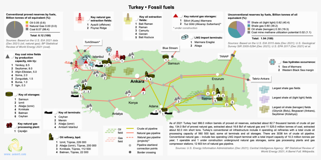
The research conducted by two Italian geologists was lapidary in warning of the risks of drilling on the Tauro mountain range, 800 kilometers long, which then declines from the summit of 3,734 meters above sea level towards the fragmented offshoots of Gaziantep (860 m asl) and Kahramanmaraş (568 m asl).
«The article deals with the geology of the foothills structure belt of the Taurus Mountains in Southeast Turkey. This area includes three main geological provinces from the south northward: (a) the foreland area, (b) the foothills structure belt, which grades into (c) the Taurus orogenic ridge» wrote in the Abstract of the research published in volume 48 of 1964 of the American Association of Petroleum Geologists the Italians M. Rigo de Righi and A. Cortesini (Source 3).
«As proved by regional geologic studies and wildcat drilling carried out by Turkish Gulf Oil Company, a 10,000-foot thick gravity slide, composed of allochthonous sheets of eugeosynclinal sediments and basic igneous rocks, was found intercalated in an Upper Cretaceous shaly-sandy sequence».
After making their technical observations as insiders, they concluded with an eloquent sentence: «After a general description of the stratigraphic units in the area, emphasis is given to the geology of the allochthonous slide complex. A general hypothesis on the origin and emplacement of these regional gravity slides is outlined. The article ends with some considerations on problems of oil exploration in areas affected by gravity slides».
3 – THE CORRELATION BETWEEN DRILLS, SUBSIDENCY AND EARTHQUAKES
Let’s jump back decades and we get to 2000 when a study by Bulent Coskun reported by Geological Magazine(source 4) introduces a well-known element of danger.
«The older structures were formed during the late Cretaceous movements, but they have been reactivated by latest Miocene tectonic activities with appearance of the Strands of the Dead Sea Fault in the sedimentary basin. The geothermal studies show also that, as a result of the Tertiary transgressions and volcanic activity, the northern and southern sectors of the Gaziantep Basin underwent differing subsidence and structural histories».
Subsidence or subsistence is a slow and progressive sinking of the bottom of a marine basin or continental area.
===============================
Skądinąd:
Turkey is heavily reliant on oil and gas imports, despite its proximity to some of the world’s largest hydrocarbon-producing countries. It imports approximately 90% of its oil and 98% of its gas requirements. Due to growing domestic energy demand, and with the government forecasting import expenditure to reach US$600 billion by 2023, there is a strategic focus on increasing domestic production. The Dadas Shale, prospective for shale gas and oil, is considered a viable way to increase domestic production.